


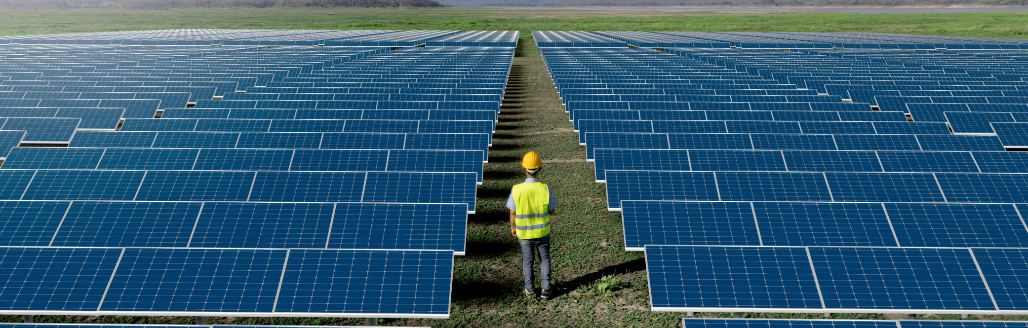
Typical Meteorological Year
Download a statistically representative “typical year” file built from 15 + years of satellite data for long-term yield modelling.
IRRADIANCE , WIND AND WEATHER DATA
Power Forecasting Models
Insights
Validations
IRRADIANCE AND WEATHER DATA
Historical Time Series
Typical Meteorological Year
Live Data
Forecast Data
POWER FORECASTING MODELS
DNV GREEN DATA PRODUCTS
Solcast is independently validated as the lowest uncertainty solar resource dataset
Vaisala 3TIER is a long-running commercial source of global satellite-derived irradiance data, with a regional focus on North America. Compared to Vaisala 3TIER, Solcast is bankable, has lower uncertainty, and offers more data features, at similar price points.
3TIER by Vaisala is a US-based solar data company acquired by Vaisala in 2013, which specialises in wind and solar resource assessment, particularly in North America. The solar dataset was first developed in 2009.
Vaisala and Solcast are both sources of global historical data and TMY, with similar price points. Unlike Vaisala, Solcast data is globally considered to be bankable, has an API with open documentation, and is free to test with instant access.
Solcast | Vaisala | |
|---|---|---|
Free trial with instant access and data download? | | |
Download wait time | 1-3 seconds | 5 minutes to 24 hours |
Comprehensive, global, independent validation | | |
Finest time resolution of satellite-based irradiance | 5 minutes | 10 minutes |
Real time data available? | | |
| |
Source: Vaisala 3TIER Services Global Solar Dataset: Methodology and Validation
Rather than focusing on the highest performance of a single dataset, Vaisala 3TIER maintains five separate datasets, based on a number of different models and cloud identification techniques. The Vaisala cloud model has a lower resolution than the Solcast model, based around a 3 km grid rather than Solcast’s 1-2km. Solcast irradiance and PV power data is also downscaled to 90 metres. Solcast has real-time data available, whereas Vaisala ends between 3 months ago and 1 day ago, depending on the product. The Vaisala coverage begins between 1997 and 1999, depending on location. Solcast only uses data from recent generation geostationary meteorological satellites (GMS). We do not use data prior to 2007 due to climate change and satellite data quality issues. This maximises data quality and validity, while still providing 15+ years of data history from which to sample for interannual variability.
Vaisala and Solcast are both globally validated, Vaisala at 196 sites and Solcast at 207 sites. In the case of Vaisala, there is a lack of independent validations, so we have to trust the results they provide. Also, Vaisala has not included DNI validation data, so we can’t compare that parameter. Solcast is more accurate and has lower uncertainty than Vaisala data. Validations show that Solcast outperforms Vaisala on all GHI measures, by a significant margin, across bias spread and RMSE.
Solcast | Vaisala | |||||
|---|---|---|---|---|---|---|
Data Version | Solcast | V1.0 | V1.1 | V1.2 | V2.0 | V2.1 |
Performed by | DNV | Vaisala | Vaisala | Vaisala | Vaisala | Vaisala |
Year published | 2023 | 2019 | ||||
No. of sites | 207 | 196 | ||||
Mean Bias | +0.33% | -0.19% | +0.17% | +0.12% | +1.65% | +1.20% |
Bias Std. Dev. | ±2.47% | ±4.37% | ±4.41% | ±4.43% | ±4.43% | ±4.09% |
Mean nMAD (nMAE) | 10.33% | 13.63% | 13.62% | 13.61% | 12.96% | 12.79% |
Mean nRMSD (nRMSE) | 15.99% | 20.78% | 20.78% | 20.77% | 20.15% | 19.94% |
Solcast | Vaisala | |||||
|---|---|---|---|---|---|---|
Data Version | Solcast | V1.0 | V1.1 | V1.2 | V2.0 | V2.1 |
Performed by | DNV | Vaisala | Vaisala | Vaisala | Vaisala | Vaisala |
Year published | 2023 | 2019 | ||||
No. of sites | 38 | 78 | ||||
Mean Bias | +0.77% | +0.22% | +0.53% | +0.58% | +2.44% | +1.88% |
Bias Std. Dev. | ±1.40% | ±3.37% | ±3.36% | ±3.35% | ±4.74% | ±4.20% |
Mean nMAD (nMAE) | 9.38% | 12.19% | 12.17% | 12.27% | 12.20% | 11.97% |
Mean nRMSD (nRMSE) | 14.75% | 19.42% | 19.40% | 19.50% | 19.45% | 19.14% |
Vaisala. (2019). Vaisala Global Solar Dataset 2019 Release.

Download a statistically representative “typical year” file built from 15 + years of satellite data for long-term yield modelling.
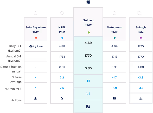
Compare multiple satellite data sets side-by-side to choose the most bankable resource file for your site.
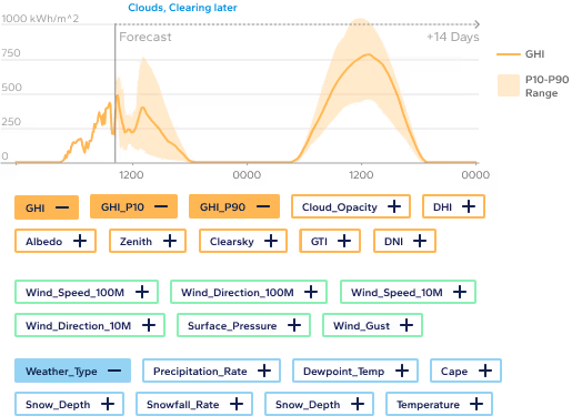
Access industry-leading solar forecasts up to 14 days ahead, combining satellite nowcasting and weather models for precision energy planning.
Subscribe to our newsletter to keep up to date with all the latest news.
Subscribe to our newsletter to keep up to date with all the latest news.